
With four weeks to fill between my last day of work and my flight to Nepal it didn’t take long to scheme up a stateside backpacking trip. My supervisor from work tipped me off to Pictured Rocks on the Upper Peninsula of Michigan a few years ago.
The Pictured Rocks lakeshore section of the North Country trail is 42 miles long. It’s a very popular kayaking and backpacking trail.
My friends Travis and Darcey were already in the mitten porting of Michigan, so we decided to meet up for the hike when they headed back towards Iowa. Ideally, you’d reserve camping permits for this trip well in advance. With our plans being last minute we had to try to acquire ours the night before we wanted to hike.
I planned to get to the visitor center an hour before it closed, but didn’t account for the time change to the Eastern Time Zone, whoops. Luckily my friends arrived just in time to get some last minute permits. The downside was less than ideal variation in the distance we would hike each day: 12, 12, 18, and 6 miles. Also, some extra distance was added to our total hike since one of our campsites was a few miles inland.
Day 1
On the morning of day 1 we broke camp at the Hiawatha National Forest campground we landed at the night we drove in and headed to Musining to catch a shuttle. After a 45 minute shuttle ride we were dropped off at the Grand Matais visitor center and hit the trail. The first 6 miles were not too exciting, just a trail through the woods and some walking along a road.
For lunch we stopped at ‘Log Slide’, a 200+ foot sand dune that goes down to the lake. I went about halfway down it before turning back, the walk back up in the sand was rough.

Looking back at the dune from farther down the trail.
A few miles after lunch we walked through Au Sable point which is home to a historic lighthouse.
From there we walked the three longest miles of the day to our first campsite, Benchmark. The campground is just inland from the dunes that run down to the beach. After setting up camp I walked down the beach in search of a place to string my hammock up and enjoy the sun and lakeshore views.

Day 2
We set out on our second day headed for a campsite that was a couple miles inland next to a lake. A lot of the hiking was inland and through the woods. We took a dip in the lake once we got to camp.
The most interesting site of the day was an abounded car in the woods off the trail.

Dude, where’s my car?
Day 3
Travis was having some problems with his boots the first couple days and walked most of day 2 in 5 finger shoes. On the morning of the third day his feet revolted and he and Darcey had to call it quits. Fortunately, there was a carpark a couple miles past camp they were able to catch a ride from. For that short hike he wore a hiking boot on one foot and a 5 finger shoe on the other, it was hilarious looking and I still regret not snapping a picture.
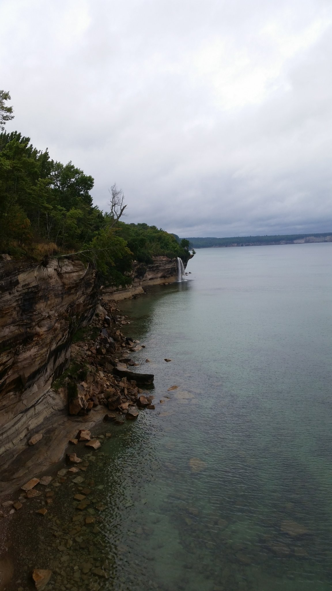
With a solo 18-mile day ahead of me I set out from camp in the rain. After passing the carpark the rain let up and the landscape started to get interesting. For several miles after the car park the trail ran through woods filled with interesting cliffs and rock formations. After that it met up with the main trail and the scenery was amazing. This stretch of the trail is where the park gets its namesake. Its an array of cliffs, arches, waterfalls, and coves all along the lakeshore.


I tried to stop as much as I could to enjoy the scenery, but with so much distance to cover the stops were brief.
The campsite for that night had “no water” marked on the map. Not wanting to backtrack for water after reaching camp I filtered 4 litres of water from a river with about 6 miles to go. I caught some funny looks from day-hikers while doing this. About 3.5 miles down the trail I realized why. There was a large, road accessible lookout complete with gift shop and tap water. This is where having time to go over the hike with the rangers before departing would have really saved me some energy!
After grinding out the last few miles I reached the Cliffs campsite. I quickly pinched my tent and set up my hammock. After lounging in the hammock for a while it started to rain and I got to test out the new tent in the rain for the first time. It kept me plenty dry and I was able to cook dinner under the vestibule during the storm.

The rain eventually broke and I sat around the fire into the evening with some friendly campmates. During the night a tree fell in the woods about 30 feet behind my tent, a little too close for comfort.
Day 4
I blew through the last 6 miles of muddy trail through the woods, hopped in my car and hit the road home.
Overall, it was a great trip. Next time I would plan in advance to get some of the prime campsites. I also would consider kayaking a good stretch of the trail as it would allow you to really get in close to some of the rock formations.

Was this the “hilarious” footwear you were referring to? I guess I never was good with fashion.
https://goo.gl/photos/DYfEn3PwsXHjphg87
LikeLike