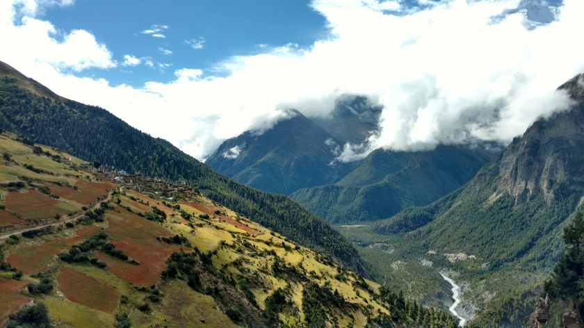
Chame is where the trek really began for Filipe and I. The guidebook suggests a 6 to 7 hour day of walking to a village called Upper Pisang. On this stage of the trail there are two options, stay on the road, or gain some elevation and take the high route, which is a proper trekking trail and free of jeeps.

Prayer flags on a suspension bridge and our first little glimpse of the peaks above.
Most of the morning was uneventful, we crossed a few suspension bridges and walked the road for a bit. After lunch we crossed the river again and had our first big uphill stretch. Eventually we reached Upper Pisang which lived up to the hype in the guidebook. It’s a proper mountain village with narrow paths between stone buildings built into the hillside.

The interior of Upper Pisang.
Upper Pisang from further down the trail.
Since it was still early afternoon we had a cup of tea and decided to try to get to the next village. After a bit of a traverse and a long bridge we were at the base of a massive uphill section. I bet Filipe it could be done in 30 minutes, he said it would take at least an hour. After fifteen minutes of hiking too fast I stopped to talk to some familiar faces. The guide with one of the other guys from our jeep said it could be done in 30 and that we were just over halfway up. I figured that was enough to prove my point and took a nice long rest with them and let Filipe catch up. In the end it was well over an hour before we reached the village of Gheryu at the top, although we did stop for tea about 90℅ of the way up.
We were rewarded with some nice views mid climb.
Random tea shop towards the top of the hill.
We finally rolled into Gharyu in the late afternoon and were accosted by the village children. They kept grabbing our trekking poles, my solution was to hold mine sideways. They took this as an invitation to use them as monkey bars. I ended up swinging them around while they hung onto the sideways poles. When it came time for the littlest ones turn I went as easy as I could. His friend tried to help him by holding him up by the waist. The kid doing the holding stumbled and ended up suplexing his buddy into the rocky ground. Many tears were shed, and that was the last we saw of the kids. On the plus side, I got to tell everyone at our lodge that night that I made one if the village kids cry, which elicits fun reactions when spoken with no context.
The one in red left in tears.
Gharyu ended up being my favorite village of the trek. We stayed at a lodge run by a mother and son and met many other trekkers we’d see again and again on the trail over the next couple weeks. I also got to try some of the 1 year old wheel of yak cheese our lodge owner was bringing to market in the morning. Aged yak cheese is delicious.
Looking back at Gharyu on our hike to Manang.
After a restless nights sleep at 3670 meters we set out for the hub of Manang. We stopped in Bragha for lunch and got to try the local Sea buckthorn juice which is quite tasty and supposedly chocked full of vitamins (and sugar). After another 30 minutes of walking down the road we were in the town of Manang. We took the next day off and just hiked around the valley.
The Gangapurna glacier as seen from Manang.
From Manang it was time to head towards Tilicho lake, the highest lake in the world. The hike to Tilicho base camp comes with many disclaimers in the guidebook. The last stretch of trail is cut through scree slopes susceptible to landslides. We stopped for lunch a few hours out from Manang and inquired about the condition of the trail. The boy working the lodge said the trail was fine and we decided to push through the last three hours to Tilicho base camp.
The view back down the valley during the hike up to Tilicho.
The view towards Tilicho. You can see the sections of scree the trail traverses in the center.
The trail was interesting, but after a few long hours we rolled into base camp at 4140 meters. Since the weather had been cloudy for the last week we made no plans to get up early for the hike to the lake. I woke up a little after six the next morning and let out a little shriek when I looked out the window. It was crystal clear out for the first time in the trek.
It took a few hours, and might have been the most difficult stretch of hiking on the trek for myself, but we eventually made it to Tilicho lake. A little before the lake you crest a hill at over 5000 meters, or 16,400 feet. It was a lot of work to get up to the lake but completely worth it. I saw two avalanches and also saw a chunk of ice calve off the glacier and fall into the lake.


what beautiful adventure you are sharing with us’thank you and be safePat and Mark.
LikeLike
That’s awesome Josh. Get the hard stuff out of the way before Tim shows up.
LikeLike
OMG Josh! What beautiful countryside! You are living a dream! Thanks for sharing with us!!
LikeLike
What an amazing trip Josh !!! So interesting and beautiful pictures, thanks for sharing them!!
LikeLike